I’ve been attempting to gather up links to photos, maps, digital documents, references and websites pertaining to Exploits-Burnt Islands. My intention, in my copious spare time, is to consolidate the information in a webpage and to continue collecting and adding to the available pool of knowledge. In the meanwhile, until I get the shell fleshed out and organised, I present to you some links I’ve found in the hopes that some will find them as interesting and useful a as did I.
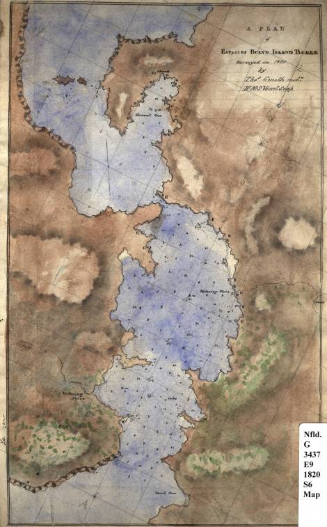
- A plan of Exploits, Burnt Island Tickle / surveyed in 1820 by Thos. Smith, mid’n. H.M.S. vessel Snap. — (clicking on the image below will take you to a larger version of the same – you may need to click on it to enlarge it in your viewer. The original is housed in the Centre for Newfoundland Studies of the Memorial University of Newfoundland)
The dark part of the map is land, btw.
And some photos of the last years of Exploits-Burnt Island from the Maritime History Archive, as a part of their Resettlement Exhibit. Clicking on each individual thumbnail will take you to the archive page for the same. An overview is here.


My favourite shot, the most poignant to my mind, is the one of people going to the last church service on the island in 1969:

More as I find it…..

These shots are really cool.
“Many Happy Returns of the day,” said Pooh to Eeyore.
Have a great one!!
Love Mom
ps I think I can do a little better than a broken ballon and an empty honey jar.
Thanks! You should never underestimate the value of A Useful Pot, though. Strange things, birthdays. You never really appreciate any one of them until you’re on the next one….
I have a grouping of old exploits pics hanging in my family room,and “The last church service” is undoubtably my favorite.